
Rivers in India: Indian river systems play a vital role in shaping the geographical, climatic and economy of the nation. From providing drinking water and supporting extensive irrigation networks to generate hydro-electric powers, river plays an integral part to human life.
For students preparing for competitive exams such as SSC and Railways, understanding the river systems of India is an essential part of the Static General Knowledge.
In this article, we will cover the major river systems in India, their origin, length, key tributaries and many more exam -oriented facts which will help you score high in exams. Rivers in India: Major River Systems and Static GK
Overview of Indian River Systems
Rivers in India are broadly classified classified into two categories based on their origin and water source:
- Himalayan River Systems (Perennial Rivers)
- Peninsular Rivers Systems (Non-Perennial Rivers)
1. Himalayan River Systems
Himalayan River systems originate from glaciers high in the Himalayan mountain range. Because they receive water from glaciers and monsoon rains, these rivers are also called as Perennial Rivers (they flow throughout the year). These rivers are long and are joined by many tributaries. The 3 important rivers originating from the Himalaya are:
| Himalayan River systems | Source of origin |
| A) The Ganges River System | Gomukh (Uttarakhand) |
| B) The Indus River System (Sindhu) | Mansarovar Lake |
| C) The Brahmaputra System | Chemayungdung glacier |
2. Peninsular River Systems
These rivers originate from the western ghats, Vindhya, Satpura or Chhota Nagpur plateaus. They are also called as seasonal rivers (rain-fed) meaning their colume drops significantly during dry months. They are divided based on the direction of flow:
| East Flowing Rivers | West Flowing Rivers |
| These rivers form delta. | These rivers do not form delta. |
| Drains into the Bay of Bengal | Drains into the Arabian Sea |
| Examples include: Mahanadi, Godavari, Krishna, Cauvery/Kaveri | Examples include: Sabarmati, Mahi, Narmada, Tapti/ Tapi |
Let us dicuss in brief about these river systems: Rivers in India: Major River Systems and Static GK
1. Himalayan River Systems
A) The Ganges River Systems
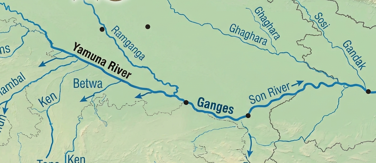
- Ganga river is considered to be the most pious rivers in India. It is the most important river in terms of the drainage system and also in terms of its cultural significance.It is one of the “longest river in the world”. It is one of the “Longest River in the World”. The “Ganga- Brahmaputra river basin” is of the world’s major river systems.
- Origin: Devparayag (formed by the confluence of Bhagirathi and Alaknanda rivers). The Bhagirathi originates from the Gangotri glacier at Gaumukh (3,900m) in Uttarakhand.
- Total Length: 2,525 km making it the Longest river in India.
- Outflow: Bay of Bengal (forms the Sunderban Delta, the world’s largest delta along with the Brahmaputra)
- The river flows through the states of Uttarakhand, UP, Bihar & Jharkhand
- Major Left-Bank Tributraries: Ghaghagra, Gandak, Kosi, Gomti, Mahananda
- Major Right-Bank Tributaries: Yamuna (Longest tributary of Ganga), Son, Punpun
Key Facts: The Kosi river is also known as the “Sorrow of Bihar” due to the frequent and unpredictable shifting of its course, causing flood in the area.
The point of merging with Alaknanda at Devprayag is referred as the Ganga river.
B) The Indus River System
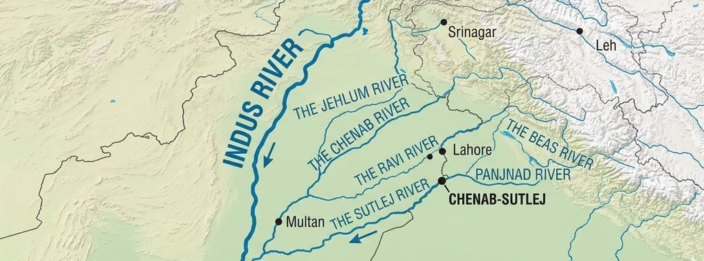
- Indus river is of the longest and most important rivers in the India subcontinent.The Indus river is also called Sindhu river system and is a part of the India’s most fertile land in the Indian subcontinent.
- This river existed way back from the “Indus Valley Civilization” era. In 1960, India & Pakistan signed a treaty for water sharing called as Indus water treaty.
- Origin: It originates from the Kailash Mansarovar in Tibet.
- It flows through the state of Jammu & Kashmir, Himachal Pradesh.
- Total Length: 3,180 km
- Outflow: Arabian Sea
- Major Tributaries: Satluj (Largest tributary of the Indus river), Jhelum, Chenab, Ravi & Beas river.
Key fact: Under the Indus Water Treaty (1960) signed between India and Pakistan, India has exclusive rights over the waters of Eastern rivers (Ravi, Beas, Satluj) while Pakistan controls the Western rivers (Indus, Jhelum, Chenab).
C) The Brahmaputra River System
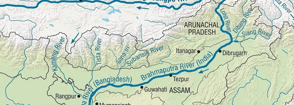
- Brahmaputra river is the trans-boundary river in Asia and is the 6th longest river in Asia. It flows through the China, India & Bangladesh.
- Origin: Brahmaputra river originates from the Chemayungdung glacier In the Tibet. In Tibet, the river is called “Tsangpo river”.
- Total Length: 2,900 km
- It enters India through the state of Arunachal Pradesh where it is called “Siang river”. In Bangladesh, the Brahmaputra river is joined by Teesta river where it is called Jamuna.
- Outflow: Bay of Bengal (It merges with the Ganga river in lower part named as Padma & finally in the final part (South) named as Meghna.
- Major Tributaries: Subhansiri, Manas, Dibang, Lohit, Teesta, Meghna, Sankosh
Key facts: Majuli island located in the Brahmaputra river in Assam, is the world’s largest inhabited riverine island.
2. Peninsular River Systems
East Flowing Rivers (Drain into Bay of Bengal)
East flowing rivers form large deltas along the eastern coast of India.
- Godavari River
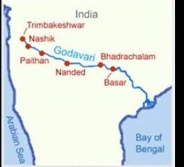
- Godavari river is an example of East flowing peninsular river.It is the largest Peninsular river system in India.It is the Second longest river of India after river Ganga. It is also known as the “Vridha Ganga” or “Dakshin Ganga”.
- Origin: It originates from the Trimbakeshwar near Nashik (Maharashtra)
- Total length: 1,500 km
- Major Tributaries: Penganga, Wainganga, Indravati, Wardha, Manjira, Bindusara, Pench
2. Krishna River
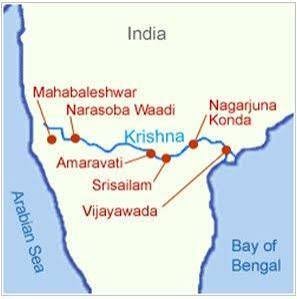
- Krishna river is an Eastern flowing perennial river in India and originates from the Mahabaleshwar near Western Ghats. It is the 2nd largest peninsular river in India after the Godavari river.
- It flows through the states of Maharashtra, Karnataka, Telangana & Andhra Pradesh and then falls into the Bay of Bengal. Krishna river basin is extensively used for agricultural purposes.
- Origin: It orignates from the Mahabaleshwar near Western Ghats
- Total length: 1,400 km
- Major Tributaries: Bhima (Longest tributary of Krishna), Tungabhadra (Largest tributary of Krishna), Ghatprabha, Malaprabha, Penner.
3. Mahanadi River
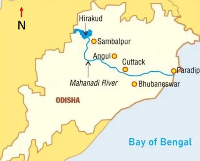
- Mahanadi river is one of the major East flowing Peninsular river in India.
- The longest Dam of India Hirakud Dam is built on Mahanadi river.
- It flows through the states of Odisha & Chattisgarh.
- Origin: It originates from a place near Sihawa located in Raipur (Chattisgarh).
4. Kaveri/ Cauvery River
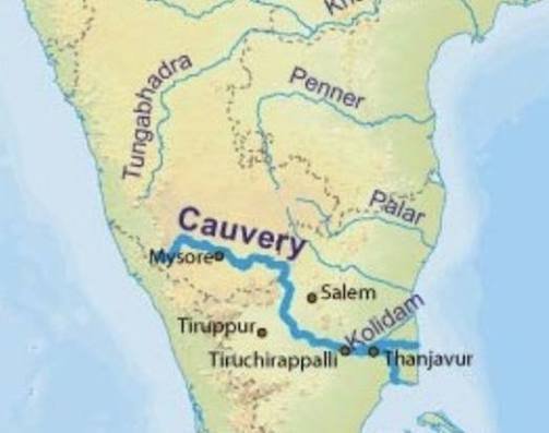
- Kaveri river is an Eastern flowing peninsular river in India.It is the 3rd largest river of South India after the Godavari & Krishna river.
- It is known as the “Ganges of the South”. Unlike most peninsular rivers, it receives rain from both the South-west and North-east monsoon.
- Origin: It originates from the Brahmagiri Hills in Karnataka and drains into the Bay of Bengal.
- Total length: 800 km
- Major Tributaries: Amravati, Hemavati, Bhavani, Shimsa, Noyyal, Tirtha
West-Flowing Rivers (Drain into Arabian Sea)
West flowing rivers pass through rift valleys between mountain ranges. They form estuaries rather than deltas because of their rapid flow down steep slopes.
- Narmada River
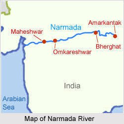
- Narmada river is the largest Western flowing peninsular river of India.It runs through the States of Madhya Pradesh, Maharashtra & Gujarat
- It passes through the 2 mountain ranges of India: a) Vidhyan Range and b) Satpura Range
- Origin: It originates from the Amarkantak Plateau near Maikal Range in Madhya Pradesh and drain into the Arabian Sea.
- Total length: 1,312 km
- Major Tributaries: Burnher, Banjar, Sher, Shakhar, Halon, Tawa
2. Tapi/ Tapti River
- Tapti or Tapi river is a river in Central India to the south of the Narmada river. It flows through the states of Madhya Pradesh, Maharashtra & Gujarat.
- The Narmada river flows parallel along the south of the Satpura range.
- Origin: It has its source from Mahadeo Hills in Satpura Range in Madhya Pradesh and drains into the Arabian Sea.
- Total length: 724 km
- Major Tributaries: Purna, Girna, Panjra
3. Mahi River
- The Mahi river is a West flowing river Peninsular river of India. It flows through the state of Madhya Pradesh, Gujarat & Rajasthan.
- Origin: It originates from the Vindhyas Range near Madhya Pradesh and flows Into the Gulf of Khambat (Arabian Sea)
- Total length: 580 km
- Major Tributaries: Som, Anas, Panam
4. Sabarmati River
- Sabarmati river is a major West-flowing river of India.It flows through the states of Rajasthan and Gujarat.
- Origin: It rises from the Aravalli Range near Rajasthan and falls into the Arabian Sea.
- Total length: 370 km
- Majot Tributaries: Watrak, Wakal, Hathmati, Harnav, Sai
Other Important Rivers
| River | States Covered | Source |
| Periyar river (244 km) | Kerala | Sivagiri hills |
| Luni river | Gujarat | Pushkar Valley of Aravalli Range (near Ajmer) |
| Subarnarekha river | Jharkhand, Orissa & West Bengal | Chhota Nagpur Plateau |
| Mandovi river | Goa | Bhimgad |
| Zuari river | Goa | |
| Shravati | Karnataka | Ambutheertha |
| Bharathapuzha | Kerala | Annamalai hill |
Frequently Asked Questions (FAQ’s)
Q1) Which is the longest river in India?
Ans: The Ganga is cnsidered as the longest river that runs entirely in India with a total length of 2,525 km.
Q2) Which is the longest peninsular river in India?
Ans: The Godavari river is the longest peninsular river in India, spanning a distance of 1,500 km. It is referred as the Dakshin Ganga.
Q3) Which rivers in India flows into the Arabian Sea?
Ans: Major west flowing rivers that drain into the Arabian Sea include the Narmada, Tapi, Mahi, Sabarmati.
Q4) Why do west-flowing rivers not form deltas?
Ans: West-flowing rivers like the Narmada and Tapi flow through narrow rift valleys with high gradients. Due to their swift current and hard rock riverbeds, they carry less slit and empty directly into the ocean forming estuaries instead of deltas.